


UPDATE: Saturday, September 11, 2021: All warnings have been discontinued for Newfoundland. Seas and winds will diminish this morning.
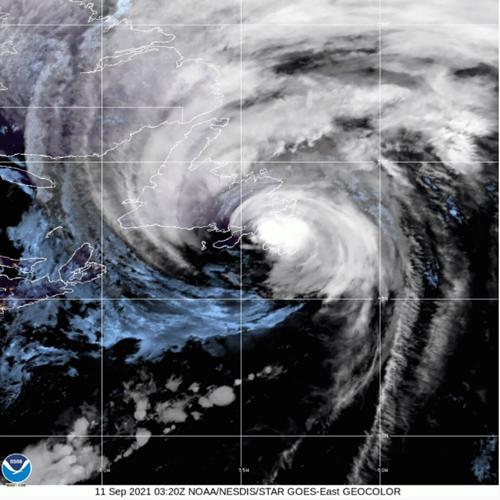
Hurricane Larry, the first storm since Igor in 2010, made landfall at Long Harbour, Newfoundland at around 1:30AM NDT Saturday morning. The storm produced a 1.5 metre (4.9 foot) storm surge at Argentia, 182km/h (113mph) wind gust at the lighthouse on Cape St. Mary, and has left over 60,000 residents without power. Winds gusted to 145km/h (90mph) in the capital St. John's as the center passed. The low pressure at landfall was an impressive 960mb.
There have been reports of coastal flooding form the storm surge, trees and power lines down and at least one roof torn from a school. The storm raced across the Avalon at over 75km/h, which resulted in rainfall totals remaining low, in the 25 to 35mm range.
Early Saturday morning, Larry was becoming post-tropical, 455km east, northeast of Cape Race, while maintaining 120km/h winds.
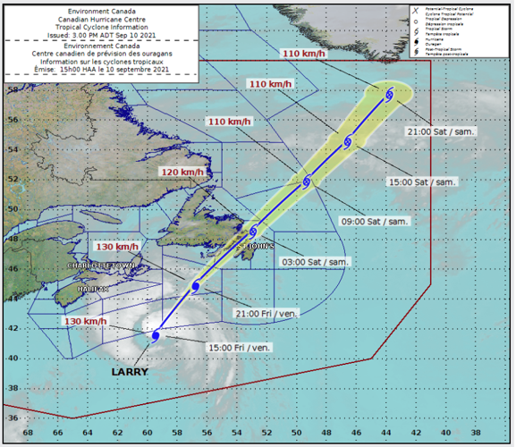
Previous Post: Hurricane Larry is expected to make landfall across southeastern Newfoundland late Friday evening. The once category 4 hurricane has been roaming the open waters of the Atlantic for over a week. Larry, now a category 1 hurricane with 130km/h winds, was located 750km southwest of Cape Race, Newfoundland at 2pm Friday afternoon. Larry was moving rapidly north, northeast at 60 km/h.
A hurricane warning is in effect for the entire Avalon Peninsula through Saturday morning. Tropical storm warnings are in effect across the Clarenville, Burin and Bonavista regions. Larry is a large hurricane, with hurricane force winds extending outward up to 150km from the center. Forecasters expect the worst of the weather across southeast Newfoundland, including St John's around midnight, lasting through 5AM Saturday morning. Wind speeds are expected in the 110km/h range with gusts up to 140km/h along coastal regions. Winds this strong are capable of knocking down trees and power lines, along with some structural damages. Residents are being urged to prepare for a strong storm through the overnight hours and expect widespread power outages.

Hurricane Larry will rapidly approach the Avalon Peninsula Friday evening while transitioning into a powerful post-tropical cyclone. The center will move towards Greenland on Saturday. (CHC)
Storm surge and coastal flooding is possible as well, with large waves accompanying Larry as it races northeast into the north Atlantic. Swells from Larry are already impacting coastal regions from North Carolina to Atlantic Canada. Rainfall from Larry will not be as significant as originally expected due to the rapid movement of the storm, with 30 to 50mm forecast.
Larry is expected to remain a hurricane through landfall tonight and then begin the transition into a strong post-tropical cyclone over the Labrador Sea on Saturday.
(0) comments
Welcome to the discussion.
Log In
Keep it Clean. Please avoid obscene, vulgar, lewd, racist or sexually-oriented language.
PLEASE TURN OFF YOUR CAPS LOCK.
Don't Threaten. Threats of harming another person will not be tolerated.
Be Truthful. Don't knowingly lie about anyone or anything.
Be Nice. No racism, sexism or any sort of -ism that is degrading to another person.
Be Proactive. Use the 'Report' link on each comment to let us know of abusive posts.
Share with Us. We'd love to hear eyewitness accounts, the history behind an article.