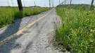
Snow squall warning ends after brief whiteout
A snow squall warning for Ottawa has ended after a brief whiteout moved across the city.
Environment Canada's weather forecast for the capital calls for cloudy conditions with flurries a high of -2 C Sunday. The expected snowfall is between 2 and 4 cm.
A snow squall watch was upgraded to a warning just before 9:30 a.m. Sunday. A line of heavy flurries moved across Ottawa between 11 a.m. and 12 noon.
Snow squall warnings remain in effect for the Brockville, Cornwall and South Frontenac areas ended just after 2 p.m.
OTTAWA FORECAST
A sharp drop in temperature is expected overnight as it plunges to a low of -22 C with a wind chill of -29.
Monday's outlook is sunny with a high of -9 C.
Tuesday is looking cloudy with a 60 per cent chance of flurries and a high of -7 C.
Wednesday's forecast includes a few clouds, a chance of flurries, and a high of -4 C.


CTVNews.ca Top Stories

Robert Pickton to remain in medically induced coma until later this week: police
Serial killer Robert Pickton will remain in a medically induced coma for at least the next few days following an attack in a Quebec prison Sunday, according to police spokesperson Hugues Beaulieu.
Poverty report cards: Which provinces got the worst grades?
Poverty and food insecurity have worsened in most of Canada in the past year and most provincial governments aren't doing enough to address the problem, according to a just-released series of report cards.
'I feel betrayed': Ottawa-area customers out thousands of dollars warn of bad faith contractor
A group of people from eastern Ontario and western Quebec is issuing a warning about Dennis Walker and his company Vue Windows.
'We'll need all hands on deck': Details emerge after deadly boat crash near Kingston
Police say they have wrapped up their on-scene investigation into a deadly boat crash in eastern Ontario as details of the incident begin to emerge.
'Five feet nothing': Pickton's safety likely behind Quebec transfer, says ex-prison judge
When serial killer Robert Pickton was transferred from British Columbia's Kent Institution to a maximum security prison in Quebec about six years ago, correctional authorities gave no public explanation or confirmation at the time, citing privacy.
Trudeau's speech to union delegates took aim at Conservatives
Prime Minister Justin Trudeau's trip to the United States targeted U.S. lawmakers, but also his political opponents in Canada, as his speech to one of the largest unions in North America attempted to make the case that his party cares more about workers’ rights than Pierre Poilievre’s Conservatives.
Woman found dead in Lake Ontario in 2017 matches identity of missing person in Switzerland
Genetic genealogy has helped Toronto police identify a woman who was found dead in Lake Ontario in 2017.
Sheldon Keefe hired as head coach of New Jersey Devils
Sheldon Keefe has been hired as the head coach of the New Jersey Devils.
Disgruntled worker fatally shoots 2, wounds 3 at linen company near Philadelphia
A disgruntled employee opened fire at a linen company near Philadelphia on Wednesday, killing two coworkers and injuring three others, authorities said.
Shopping Trends
The Shopping Trends team is independent of the journalists at CTV News. We may earn a commission when you use our links to shop. Read about us.


Atlantic
-
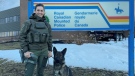
Police dog, officer find missing 4-year-old in N.B. woods
An RCMP officer and her service dog found a missing four-year-old boy in the area of Memramcook, N.B., Monday evening.
-
N.B. man arrested after stealing fuel truck, rolling it over on N.S. highway
A Moncton man is facing numerous charges – including drug trafficking – after police arrested him for allegedly stealing a fuel truck and rolling it over on a Nova Scotia highway on Sunday.
-
New air ambulance in Nova Scotia transfers non-critical patients to Halifax for tests, treatments
A new plane is transporting hundreds of non-critical patients to Halifax, saving time and keeping ambulances in their communities.
Toronto
-

Toronto-area hockey coach charged in sexual exploitation investigation
A Toronto-area hockey coach has been charged in a sexual exploitation investigation by Peel police.
-
Toronto man who stabbed, decapitated mother in 2022 found guilty of 2nd-degree murder
Dallas Ly has been found guilty of second-degree murder in the death of his mother, whom he stabbed during a dispute in 2022 before decapitating and dumping her remains on the side of the road in east Toronto.
-
‘Super pumped’: Blue Jays fan returns to Rogers Centre after being hit by 110 mph foul ball
Still sporting a black bruise around her eyes, Liz McGuire was back at Rogers Centre Wednesday night, days after being hit in the face by a 110 mph (177 km/h) foul ball.
Montreal
-

Man, 20, charged after shooting at Jewish school in Montreal last November
A 20-year-old man has been arrested in connection with a shooting at a Jewish school in Montreal last fall.
-
Montreal police say street fight that killed 3 young people was not gang-related
A violent brawl that ended with the stabbing deaths of three young people, including a 15-year-old boy, in Montreal Tuesday evening was not related to street gangs, but rather a "personal conflict," police say.
-
Tenants set to swelter after NDG building bans A/C, blocks balconies for repairs
Some tenants in Montreal's Notre-Dame-de-Grace neighbourhood are bracing for a sweltering summer. Their building on Monkland Avenue is not allowing them to turn on air conditioning because of repairs to their balconies. The repair work is expected to last all summer.
Northern Ontario
-

Sudbury, Ont., councillor speaks out after man charged with criminally harassing her
An 81-year-old man has been charged with criminal harassment of a city councillor in Sudbury.
-
Robert Pickton to remain in medically induced coma until later this week: police
Serial killer Robert Pickton will remain in a medically induced coma for at least the next few days following an attack in a Quebec prison Sunday, according to police spokesperson Hugues Beaulieu.
-
Sudburians did you feel the ground move Wednesday morning?
Earthquakes Canada and Vale confirm a 3.1 MN magnitude seismic event occurred shortly after 9 a.m. on May 22 at the Garson Mine site in Greater Sudbury, Ont.
Windsor
-
 VIDEO
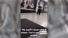
VIDEOVIDEO Student asked to leave St. Clair College campus for wearing keffiyeh
In what is being billed as an 'example of anti-Palestinian racism in Windsor,' a video circulating on social media shows a young woman denied entry to a St. Clair College facility for wearing a keffiyeh.
-
When a fight turns deadly: Windsor man on trial for death of father of 4
Ryan Taylor, 35, has pleaded not guilty to a single charge of second-degree murder for the death of 38 year old Thomas 'TJ' McIntyre. A jury of five women and seven men learned Wednesday the broad strokes of the prosecution’s case against Taylor.
-
'Farm in the City' celebrates farm life during Downtown Windsor Farmers’ Market
Tourism Windsor Essex Pelee Island and the Essex County Federation of Agriculture are bringing farm life to the city during 'Open Farms: Farm in the City' on May 25 to the Downtown Windsor Farmers’ Market.
London
-

London considers imposing 6 p.m. curfew for using gas lawn mowers and yard equipment
On Wednesday, the Civic Works Committee recommended holding a public meeting in July about whether to further restrict the hours when Londoners can use gas-powered lawn mowers, weed trimmers and leaf blowers.
-
3 teens charged after causing disturbance at west end grocery store
Three teens are facing multiple charges after allegedly throwing items at shoppers, assaulting an employee and an officer, and firing an imitation weapon at a west end grocery store on Tuesday night.
-
Thunderstorm warnings for parts of the region on Wednesday
Wednesday will be hot and steamy to start off, with a mix of sun and cloud mid morning with a chance of showers and thunderstorms as a cold front starts to move in.
Kitchener
-
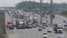
Two injured in multi-vehicle crash on Hwy 401 through Cambridge
A six-vehicle crash brought traffic to a standstill in the westbound lanes of Highway 401 through Cambridge on Wednesday morning.
-
Maple Leaf Foods closing its Brantford, Ont. plant
Maple Leaf Foods announced Wednesday that it is closing its Brantford, Ont. plant in early 2025.
-
Mayor calls out 'hooliganism' at Kitchener park on Victoria Day
Kitchener's mayor was "very disappointed and very angry" after young people were seen shooting off fireworks at others on Victoria Day.
Barrie
-
 WEATHER ALERT
WEATHER ALERT Severe storm with strong winds, hail and torrential rain hit the region
Severe storms rolled into central Ontario on Wednesday, with Environment Canada warning about 120 kilometres per hour winds that had the potential to produce a tornado.
-
Barrie, Ont. couple invited to attend Buckingham Palace Royal Garden Party
A Barrie couple who lost their home in 2021 to a tornado that devastated a south-end neighbourhood spent an unforgettable day as guests at Buckingham Palace.
-
Final touches on Cedar Point Drive project in Barrie will disrupt area businesses
Motorists travelling along Cedar Point Drive in Barrie will have noticed plenty of construction pylons and workers limiting traffic as the final touches on the restoration project get completed.
Winnipeg
-

Handwritten letters penned by admitted serial killer Jeremy Skibicki entered as evidence
A year after admitted serial killer Jeremy Skibicki was arrested for killing four Indigenous women, investigators learned he was writing to a ‘pen pal’ inmate in Nova Scotia – handwritten letters that are now being entered as evidence in his trial.
-
Man injured in Red River Ex shooting files lawsuit
An 18-year-old Winnipegger who was shot two years ago at the Red River Ex has now filed a lawsuit related to the incident.
-
Dishing out history: Gone, but not forgotten restaurants in Winnipeg
We asked, and you answered. Winnipeggers shared a number of their favourite restaurants that have since closed down, but will live forever in their memories. More restaurants generated by your submissions have been added. Take a look to see if you made the list.
Calgary
-

Calgary police release photo of suspect in hit-and-run that saw victim run over twice
Calgary police have released a photo of a man believed to be involved in a hit-and-run in Bridgeland that saw a pedestrian run over twice.
-
WestJet planning new fare category for travellers willing to forgo carry-on bag
WestJet Airlines plans to launch a new cheaper fare category that would be available to travellers willing to fly without a carry-on bag.
-
Calgary outpacing Canada's largest cities on population growth rate: StatCan
Calgary saw the highest population growth rate among Canada’s largest cities between 2022 and 2023 – surpassing 1.6 million people.
Edmonton
-

Future of Westmount Shopping Centre unclear after tenants given 30 day notice
Several business owners at Edmonton's Westmount Shopping Centre say they've been given only 30-days notice to find a new location.
-
'They're 4 and 0 in the playoffs': Burger joint feeds winning meals to Oilers
More than a year ago, a burger joint located just a few blocks from Rogers Place discovered the Edmonton Oilers had become regular customers.
-
15-year-old Edmonton boy's death being investigated by homicide detectives
A man is in custody after the suspicious death of a 15-year-old boy in Edmonton Tuesday evening.
Regina
-

'It's a heavy competition': Riders' battle for backup quarterback underway
Trevor Harris has returned from injury and will be the starting quarterback for the Saskatchewan Roughriders this season. Now, the question lingers: Who will be his primary backup?
-
Regina city councillors call to rename Dewdney Avenue 'as soon as possible'
Two Regina city councillors put forward a motion to rename Dewdney Avenue during Wednesday's regular meeting at city hall.
-
Sask. Indigenous CBC employee's discrimination claims to be heard by human-rights tribunal
An Indigenous employee with the Canadian Broadcasting Corp. (CBC) in Regina is taking up the fight against what he describes as systemic racism by his employer.
Saskatoon
-
Saskatchewan's oldest settlement considers declaring state of emergency over crumbling highway
The mayor of Cumberland House says he’s considering declaring a state of emergency over the deteriorating condition of the only highway in and out of the village.
-
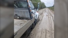
Lumber tumbles down embankment in Saskatoon freeway crash
Lanes were closed on an overpass at Idywyld Drive and 51st Street on Wednesday morning after a semi-truck overturned, spilling a pile of lumber into the ditch.
-
Calgary police search Saskatoon for man wanted in Canada-wide warrant
Saskatchewan RCMP and the Calgary Police Service are asking the public for help locating 37-year-old Michael Robertson, who is wanted by the Correctional Service of Canada on a Canada-wide warrant.
Vancouver
-

B.C.'s First Nations Health Authority hit by cyberattack
A "cybersecurity incident" at B.C.'s First Nations Health Authority nine days ago impacted some employee and other personal information.
-
Rafter found dead in Prince George identified online as MMA fighter with 'heart of gold'
A man who was reported missing after he didn't return from a rafting trip over the weekend was found dead on Tuesday, according to police.
-
'Five feet nothing': Pickton's safety likely behind Quebec transfer, says ex-prison judge
When serial killer Robert Pickton was transferred from British Columbia's Kent Institution to a maximum security prison in Quebec about six years ago, correctional authorities gave no public explanation or confirmation at the time, citing privacy.
Vancouver Island
-
Tow truck driver dead after suffering medical emergency near Victoria
A 49-year-old tow truck driver is dead after he suffered a medical emergency and drove off the highway Tuesday near Victoria.
-
Victoria council to explore building new parkade, potentially losing existing one
It's been more than three decades since the City of Victoria built a new parkade. At Thursday's committee of the whole meeting Couns. Matt Dell and Dave Thompson will be pitching the idea of building a new one.
-
B.C. family assaulted with bear spray in Walmart parking dispute
Mounties on Vancouver Island are investigating after a Walmart parking lot dispute erupted into violence in which a man and his four young children were bear sprayed by an unknown assailant.
Kelowna
-
'Altercation' in Penticton leaves 1 dead: RCMP
One person is dead after a fight in Penticton early Sunday morning, according to authorities.
-
Suspect fled in 2-door Fiat after convenience store robbery, Merritt RCMP say
A suspect is at large after robbing a convenience store at gunpoint in Merritt, B.C., Friday, according to local police.
-
Kamloops RCMP issue public warning about 2 men allegedly at centre of 'organized crime conflict'
After four targeted shootings in four days, Mounties in Kamloops are taking the unusual step of warning the public about two men they believe are likely to be targeted in future violent incidents.


