Heavy rainfall across B.C.’s South Coast, powerful winds also forecast
Posted September 17, 2021 4:20 pm.
Last Updated September 17, 2021 4:22 pm.
LOWER MAINLAND (NEWS 1130) – The final weekend of summer is a wet and stormy one across B.C.’s South Coast.
Rainfall warnings now extend from eastern Vancouver Island, across the inner South Coast, and all the way to Lytton in the Fraser Canyon, as the storm sweeps across the region.

Rain floods Great Northern Way in Vancouver on Sept. 17, 2021. (Claire Fenton, NEWS 1130)
Environment Canada says up to 80 mm of rain could soak some areas by early Saturday, which is more than what fell in many parts of B.C. over the entire summer.
Winds are also forecast to whip up to 80 km/h.
Dangerous commute
After an extremely dry summer, drivers are being warned to watch their speed, as there may be flooding on some local roads and highways.
On Friday afternoon, a multi-vehicle crash on the Port Mann Bridge shut down all eastbound traffic on Highway 1 heading into Surrey.
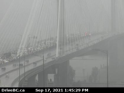
The Port Mann Bridge, looking westbound, at 1:45 p.m. on Aug. 17, 2021. (Credit: DriveBC)
While the cause of the crash is unclear, Cpl. Brad Lougheed with the B.C. Highway Patrol says the weather was likely a factor.
“I do know at this time of year, when we start to get heavy rain, people start to hydroplane due to speed and poor tires,” Lougheed said.
“People who don’t have proper tires when they’re driving at higher speeds on the highway, and it’s heavy rain, there can be a little bit of pooling of water on the highway, which causes the vehicle to hydroplane. Generally, if they’re not an experienced driver or they’re not aware of what’s happening, they can lose control of the vehicle.”
Hello Raincouver. It's been awhile. pic.twitter.com/f1a6YRlZGP
— Claire Fenton (@Ceeceefenton) September 17, 2021
Darren Ell with Mainroad Lower Mainland Contracting says for many drivers, this storm will mean a bit of a “re-learning curve.”
“The big thing is for people to slow down, that’s the key,” he said.
Crews will be sent to keep an eye on trouble spots, to clear catch basins, and to get rid of pooling water.
“We’ll be putting extra crews on shift to go patrol the roads, and if there is any ponding or any backups, we’re going to mitigate that ponding as soon as possible. Because it is one of our first rains, we’re expecting some debris on the catch basins and the drainage barriers,” he explains.
#SkyTrain Expo Line is experiencing delays in the area of Columbia & New Westminster Stations due to flooding. Updates to follow. ^cm
— TransLink BC (@TransLink) September 17, 2021
Water levels expected to rise
A high streamflow advisory continues for Metro Vancouver and the South Coast due to these heavy rains. That could be upgraded to a flood watch at a moment’s notice.
BC River Forecast Centre Hydrologist Jonathan Boyd says while a high streamflow advisory covers much of the South Coast, some areas will be hit harder than others.
“In West Vancouver and North Vancouver, rivers like the Seymour and Capilano and Coquitlam River, and even further into the valley and the Alouette or Stave rivers. Those are the highest, along with some areas in the Sea to Sky corridor,” he explained.
Boyd calls it a “dramatic change of seasons.”
“It’s going to be a sudden and almost unexpected rise, in terms of the rivers and creeks in the region. Having the first major storm of the season really creates a lot of uncertainties,” he said, adding the region has been under drought conditions for the past several months.
“The flows on rivers and creeks are extremely low right now. A lot of the area has been quite dry and vegetation is thirsty. With that, when we do have the first rainfall event of the season, sometimes the response can be muted a bit because of the ground soaking in that rain.
“However, this storm is quite strong so there are concerns that due to the dry preceding conditions, there might be a little more overland flow. We do expect flows to increase quite rapidly.”
Possible power outages?
As of 2 p.m. Friday, the storm had not caused any significant outages, but all BC Hydro customers are being told to prepare with a well-stocked emergency kit just in case. Susie Rieder with the utility says crews are on standby and have contractors ready in the event the storm worsens.
BC Hydro has also released a new report predicting a busy season ahead for its crews.
“Record-breaking summer temperatures in B.C. could mean more dead or weakened trees that pose a risk to electrical infrastructure this storm season,” Rieder said about the report, The perfect storm: How summer drought could mean severe fall storm fallout.
Making the situation worse, La Niña is predicted to bring colder and windier weather into the South Coast this fall. BC Hydro predicts it could create a “perfect storm” for power outages.
“This year on the South Coast we are concerned because the drought has caused a lot of vegetation that’s used to a lot more rain to dry out. So it’s weakened trees and vegetation. So this means on the South Coast especially in city centres where there are dense tree canopies and powerlines there could be a potential for more outages in places like Abbotsford and Downtown Vancouver,” Reider explained.
The bright side is that despite increasing storms and more power outages, BC Hydro says the five-year average shows that outage times are decreasing, so customers aren’t in the dark as long.
She says they do have crews on standby, and always have contractors ready to roll out if the storm worsens.
With files from Sonia Aslam